
General objectives
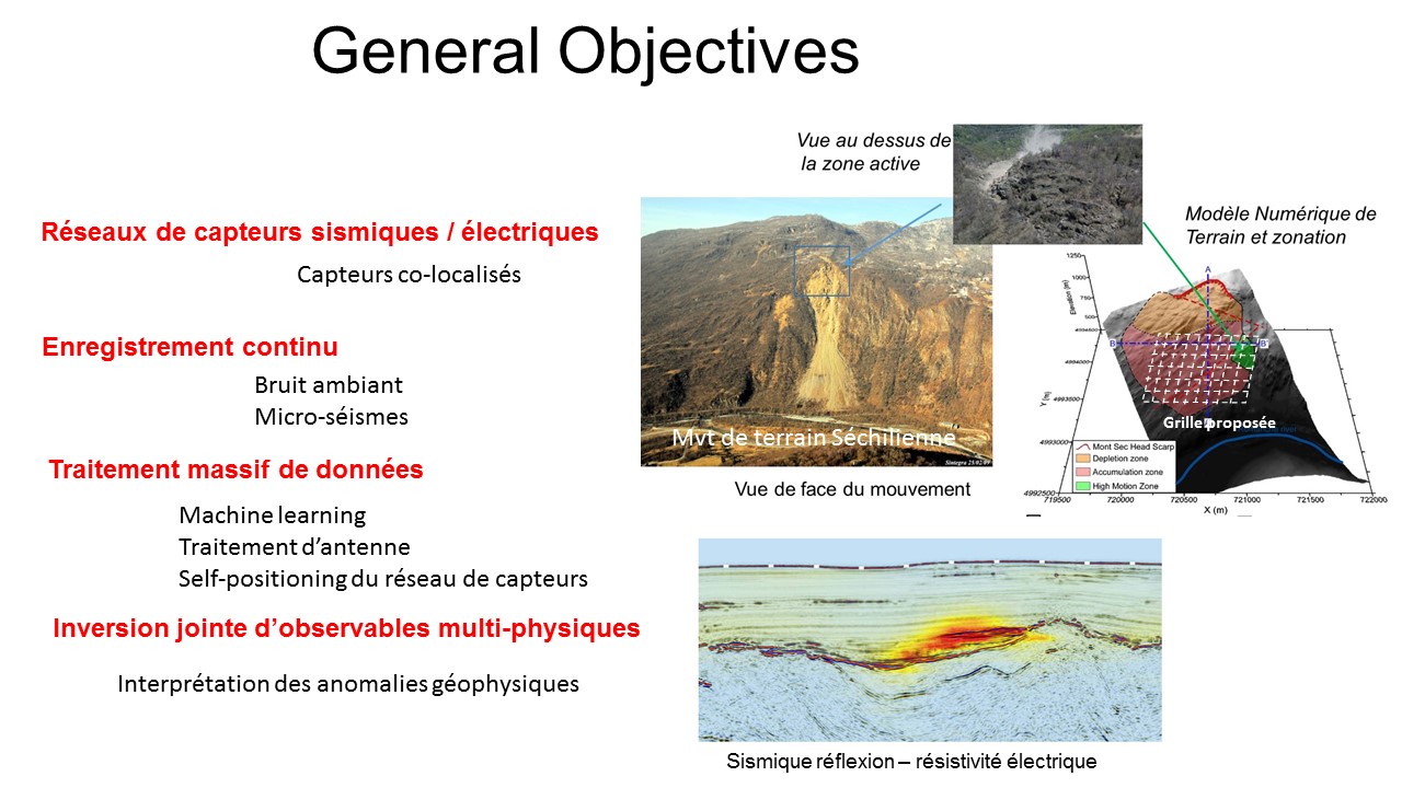
The RESOLVE project intends to lay the foundation for modern geophysics by gathering advanced signal processing and quantitative interpretation on a unique multi-instrumental platform. These different aspects of the RESOLVE project are summarized in the form of keywords described below :
Array of sensors
Whatever the scale and the nature of the observables (seismic & electric fields), the scientific objectives of multi-element arrays system are (i) to provide 3D spatial resolution. This applies to both active and passive systems, and for combined source–receiver systems (Rost & Thomas, 2002) ; (ii) to provide observable separation as, for example, in the presence of wavelet superposition due to reflections from multiple interfaces. (iii) to bring new observables, such as incident angles that can be combined with classical amplitude and time information, to further improve image resolution (Aulanier et al, 2013). What is true for seismic arrays is also true for electrical field arrays that can feel the diffusion of electromagnetic disturbances.
Continuous recordings
A new trend in geophysics is the use of continuous ambient noise (seismic or electromagnetic) recorded on dense arrays to create surrogate active sources from purely passive multi-element systems. Turning passive systems into active ones through cross-correlation processing has revolutionised the use of seismic arrays for subsurface imaging at local and regional scales. In a similar way, new algorithms were proposed for passive electrical signals (Slob et al., 2010). RESOLVE proposes now to break another barrier : the spatial and temporal resolution of images produced by densely populated multi-instrumental arrays (both seismic and electric).
Advanced signal processing
There are different ways to take advantage of new massive datasets that gather continuous measurements of different types (e.g. electric and seismic, for example). The simplest way is through statistical analyses : when processed with classical methods, new observables can add redundancy to the existing inversion procedures, such that the bias or errors in the final geophysical image can be reduced. Another way that is more challenging is to seek for new information inside the data, by using, for example, advanced array-processing methods (Letouze et al., 2012) and multi-observables joint inversion as proposed in the RESOLVE project.
Quantitative interpretation
To reduce the non-uniqueness in interpretation, recently implemented approaches are using multiple geophysical datasets which have complimentary sensitivity maps (Tiberi et al., 2003). Various structural approaches have been developed for the joint inversion of geophysical data (Haber and Oldenburg, 1997) or for data fusion. RESOLVE aims at developing these approaches taking advantage of new high-resolution observables focused on physics processes that share fluid substitution issues.
Updated on 21 mars 2018
